To mitigate seismic risks in communities, urban planners often restrict construction over known active fault lines. Buildings over these faults face severe damage from fault movements, which can be horizontal, causing shearing to foundations, or vertical, leading to structural distortions. Such damage typically exceeds that caused by ground shaking. Buildings on ruptured faults are prone to collapse, significantly raising the potential for casualties. However, the overall impact on cities is limited due to the narrowness of surface fault zones, often just tens of meters wide. Examples of surface fault ruptures from the 2023 Mw 7.7 and Mw 7.6 earthquakes in Türkiye can be seen in the following figures below.
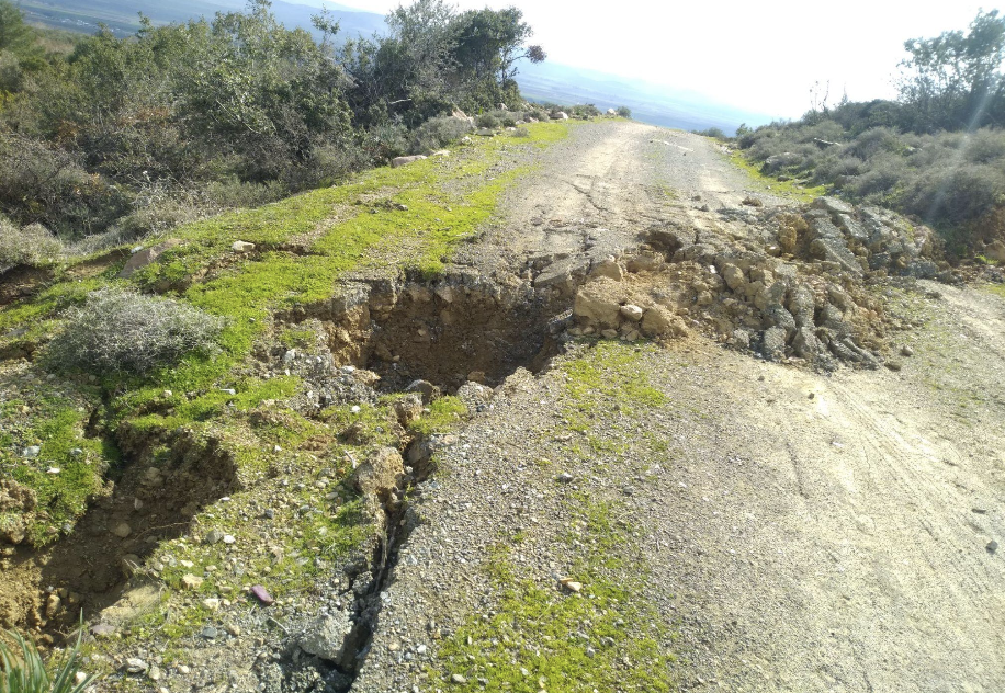
Source: From X post by @umutcelil40
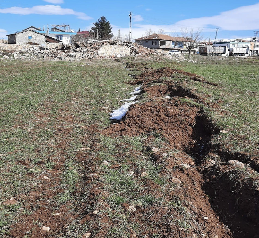
Source: From X post by @ersenma
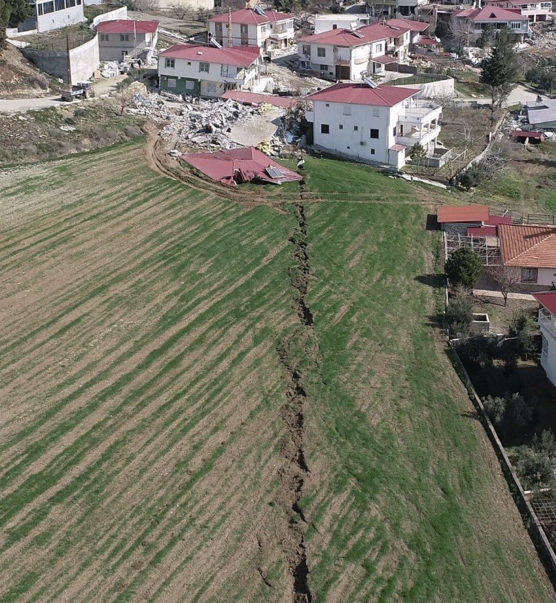
Source: Photo by Jiannan Meng
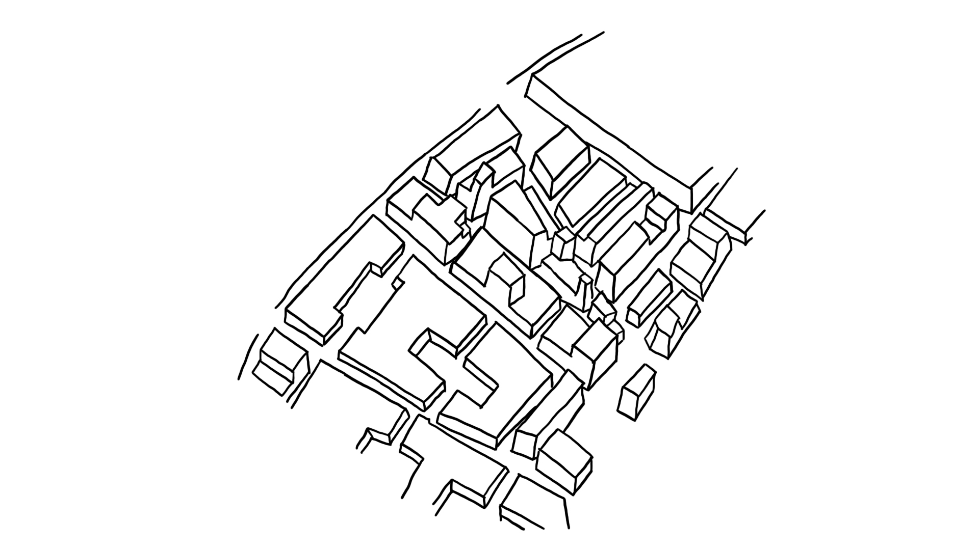
Legislation like the Californian Alquist-Priolo Earthquake Fault Zoning Act of 1972 mandates identifying and delineating active fault zones. This law requires a 15-meter setback from active faults for new buildings intended for human occupancy, with some exceptions like lightweight single-family homes. New Zealand’s guidelines are similar but also consider additional factors like fault location accuracy, recurrence intervals, and the building’s significance to the community (Figure below).
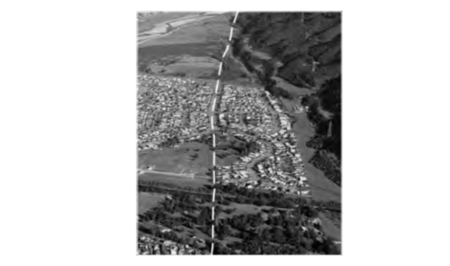
Figure 15.2 Suburb is planned so that an active fault passes through a green strip in New Zealand. From SDA Pg. 236.
The importance of such regulations was highlighted by the July 2007 earthquake damage to Japan’s Kashiwazaki nuclear power plant, which was built directly above an active fault line. This event, characterized by a noticeable crevice running through the plant, underlines the critical need for stringent building guidelines in areas with seismic activity.
Location Decisions
Choosing the right location for urban development projects is crucial in preventing future disasters, particularly in seismically active areas. Seismic zonation, and more specifically microzonation, are essential tools for identifying suitable locations. When selecting a site, factors such as topography, landslide risks, rockfall potential, liquefaction susceptibility, soil dynamics, and foundational aspects must be considered (Figure below (left)). It’s important to distribute activity centers optimally while avoiding the placement of sensitive public buildings in areas with potential seismic risks. Development should be avoided in areas with slopes and unstable soils due to their high-risk nature (Figure below (right)). The design of streets and public boundaries significantly contributes to creating a positive, attractive, and safe public environment. Effective boundary treatment should balance visibility into adjacent public spaces while ensuring privacy for building occupants. It should also clearly define the edges between public, communal, and private open spaces. Incorporating extruding and recessed forms in the design helps in creating semi-private open spaces that enhance the street environment. Additionally, the inclusion of level changes in the design can offer privacy to internal spaces of buildings. This approach in urban design and planning integrates safety, functionality, and aesthetics, ensuring that urban spaces are not only resilient to seismic events but also conducive to positive public interaction and privacy.
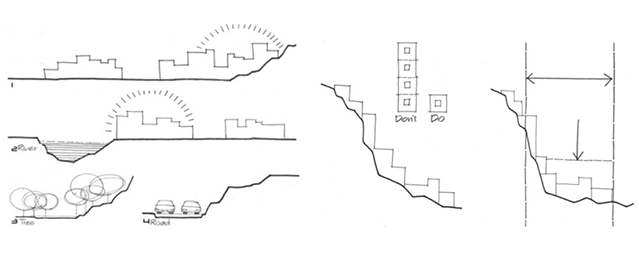
Figure 7.3 Considerations in site selection decisions & Figure 7.4 Prevent from slope and instable soil. From UDSPR Pg. 251.
Guidelines for Roads and Open Spaces
Prioritizing the creation and access to open spaces is essential, particularly for disaster management. The first priority often involves ensuring access to these spaces, with their development being the second priority (Figure below). Concurrently, the improvement and strengthening of road infrastructure are crucial, with road enhancements being a secondary focus after ensuring structural robustness. Removing non-structural elements that could cause damage is also a top priority. This is closely followed by ensuring accessibility for emergency situations, which is vital for effective disaster response. In terms of urban development, urban renewal is frequently a primary objective, with partial repairs and physical improvements being the next in line of importance.
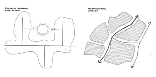
Figure 7.7 Maintain a short distance between blocks. From UDSPR Pg. 253.
Repair strategies and measures to facilitate access to both existing and proposed open spaces outside the area are also prioritized. Alongside this, physical improvements are considered to enhance the overall resilience and functionality of the area. Additionally, the areas are assessed for their specific needs in disaster scenarios, such as providing better access during emergencies and implementing measures to prevent and control fires. Improving the physical layout to prevent fire spread is a significant aspect of these measures. The focus is on a balanced approach that includes strengthening infrastructure, enhancing access and safety during disasters, and improving physical layouts to mitigate risks, all while prioritizing urban renewal and the development of open spaces (Figure below).
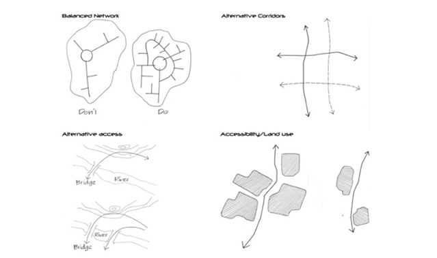
Figure 7.8 Balanced network, alternative corridors, and access. From UDSPR Pg. 254.
Separation Between Buildings
During earthquakes, buildings can suffer damage due to “pounding” if seismic separation gaps between them are not wide enough. Modern building codes now require these gaps to prevent buildings from drifting across site boundaries and damaging neighboring structures (Figure below). The width of these gaps varies based on a building’s flexibility and height. For instance, a very flexible 10-story building with an inter-storey height of 3.5m would require a gap of 700 mm at the roof level. Although this gap could theoretically taper from ground to roof, practical construction concerns often dictate a uniform gap width.
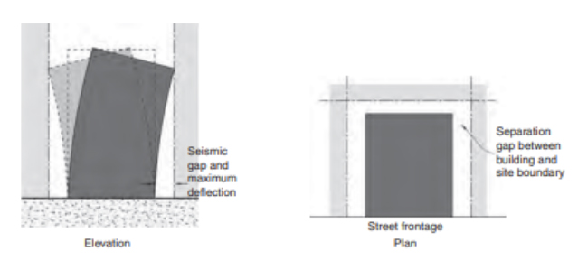
Figure 8.24 Separation needed in both elevation and plan. From UDSPR Pg. 137.
To mitigate this risk, modern seismic design includes measures like adequate spacing between structures, use of energy-absorbing materials at potential impact sites, and retrofitting older buildings to withstand lateral forces.
Decentralization
Decentralized concentration at the city scale can be an effective strategy to mitigate earthquake risk, especially by preventing high-density development in inner city areas. This approach involves spreading out activity centers across the city, creating self-sufficient districts or neighborhoods. Such decentralization not only reduces seismic risk during and after disasters but also ensures easy and safe access to public spaces and activity centers for residents (Figure below). Decentralizing open spaces is another crucial aspect, facilitating safe and quick access for people in surrounding areas. This concept extends to providing alternative access routes to public services, enhancing safety and accessibility in emergency situations.
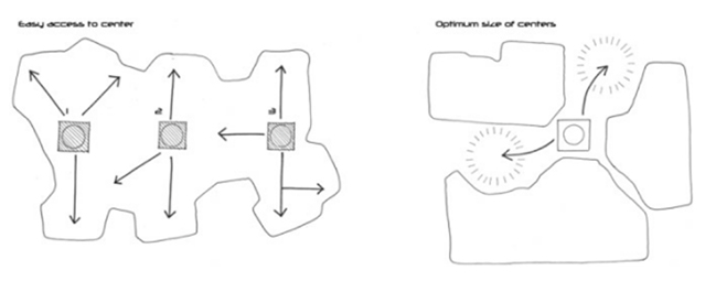
Figure 7.16 Easy and safe access to centers. From UDSPR Pg. 258.
Applying seismic standards to the decentralization of public utilities and services is vital. This ensures that these essential services remain operational during and after seismic events, contributing significantly to the city’s resilience. Additionally, understanding and planning for how fire spreads within and between buildings is essential. Decentralizing public utilities and services with seismic considerations can prevent or limit fire spread, further safeguarding the city’s infrastructure and its inhabitants (Figure below). Decentralized urban planning, combined with seismic safety measures, offers a comprehensive approach to reducing earthquake risks, enhancing public safety, and ensuring continued access to essential services in times of disaster.
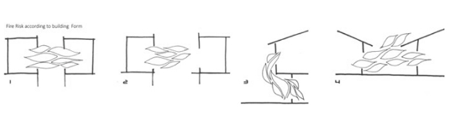
Figure 7.19 Fire spreading to buildings. From UDSPR Pg. 259.
Land-Use Performance
The guidelines emphasize the importance of land use in reducing risk and increasing resilience. Land uses are categorized into sensitive (like education and health centers) and non-sensitive, as well as vulnerable and potentially damaging (like gas stations and pipelines). The distribution of these land uses, based on their dependence on consumers and their spatial structure, is critical. Factors such as topography, proximity to faults, and infrastructure networks also play a significant role in determining land-use vulnerability. Careful planning and design of land uses, particularly their locations, can significantly mitigate vulnerability to earthquakes and prevent secondary damages such as fires.
Open and green spaces, typically used for recreation, become crucial for rescue and relief in disasters. Their accessibility is especially important in dense, older city areas. The guidelines also highlight that higher human density in certain land uses, like schools and hospitals, increases the risk of human losses, underscoring the need for fast and safe evacuation standards. Building density in high-rise and densely packed urban areas can compound losses and make emergency service delivery challenging. The guidelines also note the dangers of liquefaction-prone areas, especially in city centers with old infrastructure and high density. The presence of incompatible land uses in residential areas poses additional risks. The settlement patterns of low-income families on city margins, often disregarding earthquake hazards, increase the vulnerability of these peripheral areas. By considering seismic hazards and other natural factors in urban spatial planning, and by addressing population and physical state issues, cities can significantly reduce their vulnerability to earthquakes. This requires seismic microzonation studies for each urban area, considering regional earthquake ground motions and local conditions.
Referenced from:
Seismic Design for Architects (SDA)
By Andrew Charleson
Published in 2008
Urban Design in Seismic-Prone Regions (UDSPR)
By Hoosein Bahrainy & Ameneh Bakhtiar
Published in 2022
Discussed in:
ARCH 332 Chapter 7 (Insufficient Spacing)