In Turkey, the vulnerability to earthquakes is a critical concern; a significant 92% of the country’s land, accommodating 95% of the population and hosting 98% of industrial facilities, lies within earthquake-prone areas. Furthermore, 92% of the nation’s dams are situated in these high-risk zones. With regard to seismic threat, 21.5% of the population resides in the most hazardous first-degree earthquake zones, and an additional 31.4% live in second-degree zones.
Tectonic Setting of Türkiye
Türkiye, situated in a complex tectonic zone, experiences heightened seismic activity due to the interaction of multiple tectonic plates. The convergence of the Arabian, African, and Eurasian plates with the Anatolian plate, positioned between the Aegean Sea and the Iranian Plateau (Figure below (Top)), defines Türkiye’s tectonic setting. Active faults, such as the East Anatolian Fault (EAF), North Anatolian Fault (NAF), Sungurlu Fault (SF), Ovacık Fault (OF), and Dead Sea Fault (DSF) (Figure below (bottom)), play a significant role in accommodating tectonic deformation, posing a significant seismic hazard.
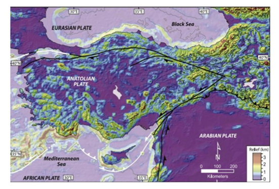
Figure 1. Convergence of the African, Arabian, and Eurasian plates with the Anatolian plate (Schildgen et al. 2014). From PVRR Pg. 24.
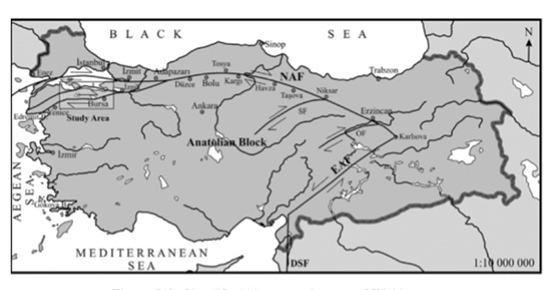
Figure 2. Simplified Neotectonic map of Türkiye (Selim & Tüysüz 2013). From PVRR pg. 26.
The NAF facilitates westward movement of the Anatolian block against the Eurasian plate, leading to right-lateral strike-slip motion. Notably, the NAF has triggered devastating earthquakes, including the 1999 M7.6 İzmit earthquake. The EAF, spanning over 1200 km, manages the eastward motion of the Anatolian block against the Arabian plate, causing significant earthquakes like the 1983 M6.9 Erzurum earthquake. The DSF, a major transform fault, intersects with the EAF in southeast Türkiye, contributing to the complex tectonic dynamics of the region.
In this seismically active region, three earthquakes of magnitude 6 or higher have occurred within 250 km of the Feb.6, 2023 Mw 7.7 earthquake since 1970. Noteworthy is the historical seismicity of southern Türkiye and northern Syria, exemplified by Aleppo’s devastating earthquakes in 1138 and 1822, with estimated magnitudes of 7.1 and 7.0, respectively, resulting in significant fatalities. Despite relative seismic quiescence in the recent epicentral area, the region has a history of impactful seismic events.
2023 Mw 7.7 and Mw 7.6 Earthquakes Features
On February 6, 2023, a seismic sequence unfolded in Pazarcık, Kahramanmaraş, with an initial Mw 7.7 earthquake striking at 4:17 am local time, followed by a subsequent Mw 7.6 event in Elbistan at 1:24 pm local time. The first quake, located at 37.288°N, 37.043°E with an 8.6 km depth, was followed by a second earthquake at 38.089°N, 37.239°E and a depth of 7 km (AFAD 2023b, c). Over 300 aftershocks occurred in the region within 48 hours, reaching magnitudes up to Mw 6.6 by February 9, 2023 (AFAD 2023b).
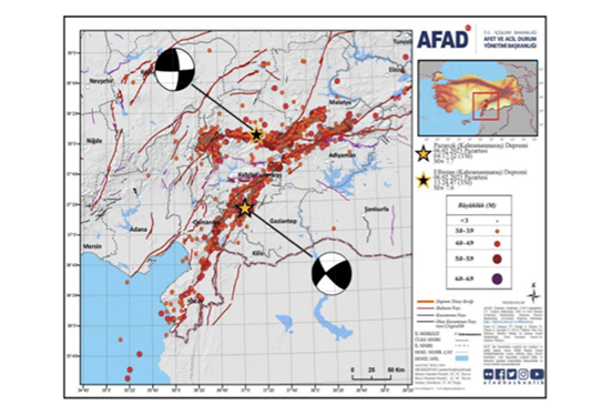
Figure 3. February 6, 2023 Mw 7.7 & Mw 7.6 Earthquakes and corresponding aftershock activity (AFAD 2023b). From PVRR Pg. 23.
The finite fault model suggests that the Mw 7.7 earthquake resulted from shallow strike-slip faulting, rupturing over three fault segments near the triple-junction of the Anatolian, Arabian, and African plates (USGS 2023a). The earthquake’s mechanism and location are consistent with the EAF and DSF systems.
The Mw 7.6 earthquake, occurring 95 km northeast approximately nine hours later, also ruptured over three fault segments near the triple-junction of the Anatolia, Arabia, and Africa plates. The earthquake’s location and mechanism, along with subsequent aftershocks, align with the broader EAF zone (USGS 2023b). Figure below illustrates the relative ground displacement observed after the Mw 7.6 event, consistent with the expected shallow strike-slip mechanism.
Figure 4. Fault slip of 3.0 to 3.5 m at the Anatolian plate from the February 6, 2023 earthquake sequence (adapted from reddit post by u/kebabG 2023a. From PVRR pg. 29.
Evolution of Seismic Zonation and Current Seismic Hazard Maps
Between 1985 and 2018, Türkiye witnessed the evolution of seismic hazard estimates through the integration of findings from eight national and international studies (Akkar et al. 2018). The culmination of this effort materialized in the 2018 model, known as T-SHM (The revised National Probabilistic Seismic Hazard Maps), initiated in 2013 under the guidance of AFAD within the National Earthquake Strategy and Action Plan-2023.
Before 1996, Türkiye’s zonation maps were primarily based on building damage or macroseismic intensity, reflecting observed seismic risk rather than hazard. These maps lacked smooth transitions between seismically active and “non-seismic” regions. In contrast, the 1996 map utilized PGA (peak ground velocity) as the ground motion intensity parameter, introducing a refined seismic zonation framework. Figure below illustrates seismic zonation maps in Türkiye from 1945, 1963, and 1996, highlighting the expanding areas designated as high active seismicity regions over the years.
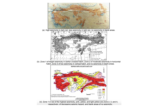
Figure 5 Evolution of the seismic zonation maps in Türkiye: (a) 1945, (b) 1963, and (c) 1996 (Akkar et al. 2018). From PVRR pg. 31
Unlike its predecessors, T-SHM (Figure below) introduced a significant overhaul, incorporating new features and improvements. This strategic initiative, led by AFAD, facilitated a more thorough evaluation of Türkiye’s seismic hazard landscape. Notably, the 2018 model departed from the conventional zonation maps that previously assumed constant values of plausible seismic demands within five zones, irrespective of the distance from the fault.
In the current 2018 regulation, the direct earthquake design spectrum is automatically calculated based on location coordinates by the relevant ministry’s webpage according to the soil type (AFAD: Türkiye’s New Earthquake Hazard Map).
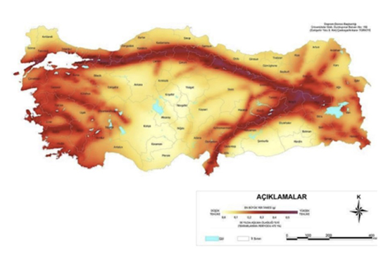
Figure 6. Seismic Hazard Map of Türkiye (2018). Fom PVRR pg. 32
Referenced from:
Joint Preliminary Virtual Reconnaissance Report (PVRR)
By Abdullah et al.
Published in 2023
Revised probabilistic hazard map of Turkey and
its implications on seismic design.
By Akar et al.
Discussed in:
ARCH 331 Lecture 1A (Load Regulations, EQ Plates and Zones of Turkey)